


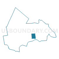
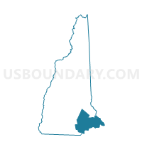
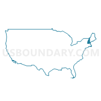
TOWN OF KENSINGTON Voting District, Rockingham County, New Hampshire
About
Outline

Summary
| Unique Area Identifier | 616413 |
| Name | TOWN OF KENSINGTON Voting District |
| County | Rockingham County |
| State | New Hampshire |
| Area (square miles) | 11.96 |
| Land Area (square miles) | 11.94 |
| Water Area (square miles) | 0.01 |
| % of Land Area | 99.88 |
| % of Water Area | 0.12 |
| Latitude of the Internal Point | 42.93134790 |
| Longtitude of the Internal Point | -70.95780910 |
Maps
Graphs
Select a template below for downloading or customizing gragh for TOWN OF KENSINGTON Voting District, Rockingham County, New Hampshire


Neighbors
Neighoring Voting District (by Name) Neighboring Voting District on the Map
- TOWN OF EAST KINGSTON Voting District, Rockingham County, NH
- TOWN OF EXETER Voting District, Rockingham County, NH
- TOWN OF HAMPTON FALLS Voting District, Rockingham County, NH
- TOWN OF SEABROOK Voting District, Rockingham County, NH
- TOWN OF SOUTH HAMPTON Voting District, Rockingham County, NH
Top 10 Neighboring County Subdivision (by Population) Neighboring County Subdivision on the Map
- Exeter town, Rockingham County, NH (14,306)
- Seabrook town, Rockingham County, NH (8,693)
- East Kingston town, Rockingham County, NH (2,357)
- Hampton Falls town, Rockingham County, NH (2,236)
- Kensington town, Rockingham County, NH (2,124)
- South Hampton town, Rockingham County, NH (814)
Top 10 Neighboring Elementary School District (by Population) Neighboring Elementary School District on the Map
- Exeter School District, NH (14,306)
- Seabrook School District, NH (8,693)
- East Kingston School District, NH (2,357)
- Hampton Falls School District, NH (2,236)
- Kensington School District, NH (2,124)
- South Hampton School District, NH (814)
Top 10 Neighboring Secondary School District (by Population) Neighboring Secondary School District on the Map
- Exeter Regional Cooperative School District, NH (32,208)
- Winnacunnet Cooperative School District, NH (30,660)
Top 10 Neighboring State Legislative District Lower Chamber (by Population) Neighboring State Legislative District Lower Chamber on the Map
- State House District 13, Rockingham County, NH (25,862)
- State House District 14, Rockingham County, NH (13,867)
- State House District 11, Rockingham County, NH (6,960)
Top 10 Neighboring State Legislative District Upper Chamber (by Population) Neighboring State Legislative District Upper Chamber on the Map
Top 10 Neighboring 111th Congressional District (by Population) Neighboring 111th Congressional District on the Map
Top 10 Neighboring Census Tract (by Population) Neighboring Census Tract on the Map
- Census Tract 1062, Rockingham County, NH (4,331)
- Census Tract 1064, Rockingham County, NH (4,022)
- Census Tract 630.01, Rockingham County, NH (3,728)
- Census Tract 625, Rockingham County, NH (2,938)
- Census Tract 620, Rockingham County, NH (2,357)
- Census Tract 640, Rockingham County, NH (2,236)